
(Majorca) Mallorca's most spectacular hike: climbing the Penyal des Migdia
- Feb 6, 2023
- 4 min read
Updated: Jul 16, 2024
The hike to Penyal des Migdia, Mallorca's second highest mountain, is the most spectacular and challenging on the Balearic Island. You need to be sure-footed, have a head for heights and be prepared. Here you can find everything you need to know:

The Penyal des Migdia towers over the valley of Soller like an impregnable fortress. From the west, all that can be seen is a smooth wall about 500m high. At 1398m, it is the highest climbable peak on Mallorca after the Puig Mayor, which lies in the restricted military area
Key Facts for the hike to the Penyal des Migdia/Mallorca
♡-Factor: ♡♡♡♡♡
Starting point: Park just before the 38km stone from the MA10 between Soller and Pollenca.
Duration: 4:30 hours
Route: 7 km
Difference in altitude: 530 m. up and down
Bar: None
Note: The hike is short and crisp, includes climbing sections and is very exposed on the summit ridge. Orientation is not always easy on the path marked with cairns and the descent on trackless, gravelly terrain should not be underestimated.
Conclusion: Great trail, which I have now also done in good weather. Only recommended for sure-footed hikers with no fear of heights in good weather - otherwise things can get really hairy.
I have saved the hike with GPS Data for you in Outdooractive.

A Mallorcan acquaintance told me some time ago that you have a magnificent view akter the hike to the top of the Penyal des Migdia. Migdia means noon, because the ridge of the peak runs exactly from east to west, so the mountain can be seen from the valley like a giant sundial. I think our acquaintance's ascent was also a few years ago, because he told us that you can already drive up almost to the top of Puig Mayor via the road to the summit and then only have to scramble up to the top for half an hour over gravel. The road is closed today - except for the military - and even so, the hike is not listed in any common hiking guide. When I finally found a description at outdooractive , it said that the hike was difficult and absolutely not recommended in fog and only from March to October ... Here you can read about my experience of the hike up to the summit of Penyal des Migdia in Mallorca.
Click on the first photo to start the photo gallery - with picture description:


Description:

You park just before the 38km stone from the MA10 between Soller and Pollenca. From there, a wide track leads up the mountain through a gate on the left. We also follow this through the second gate, which can be bypassed on the left. Continue along the gravel road past a spring until you cross a mountain saddle (Coll des Cards Colers - 903m). There is a metal cross on the left. We follow the gravel road for another 400m or so until the terrain next to the path on the right briefly flattens out before dropping down.

From here the orientation gets more complicated
Here, the hike begins to require some imagination, because on the right - in the high grass - the path now leads past cairns up the mountain flank. Rough orientation: the radar dome of the Puig Mayor. Our problem? Rising fog! Eventually we were able to shimmy from cairn to cairn. The path goes up and up and after a wide gravel pile the path crosses briefly to the right and then turns into a bit of climbing before reaching the summit plateau. Our visibility was zero and so one stopped at the cairn while the other looked for the next one. The edge to the western steep face then came as a bit of a surprise ... the wind was cold, we couldn't see anything and we also preferred not to look for the way back again. Fortunately, a couple from Berlin had set off at the same time as us and - because of the difficult conditions - we had always stayed in sight.
My advise: Don't do this hike in bad visibility
Up here, however, we became quite attached, as the man had a GPS device and we - as usual, of course: nothing! Together we followed the steep edge to the left

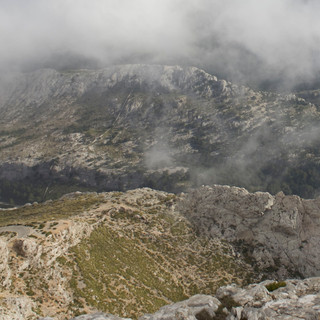
(in the direction of Puig Mayor, if you can see it ...), soon the ridge rises again and so you first get to a mini summit cross and a bit further to stone walls. the ridge is quite exposed which we didn't see that way the first time in bad weather ... The clouds broke up now and then and from here you really have a spectacular view of the Cuber all the way to Puig Roig, but also down to Soller. Huge birds (we hope they weren't vultures :;)!) sailed through the clouds at the same height as us. At the bottom right you can see the road our friend told us about.

The descent is equally challenging
A steep gravel gully leads down to it - by far the most unpleasant section for me. No sooner had I set foot on the road than a military truck came along, wanting to know where we were going. Since the
When the hiking trail winds steeply down the slope to the right at the next left-hand bend, the soldiers were satisfied and we were allowed to continue. A last friendly wave to the surveillance cameras and then we followed the gravel path along the fence until you can slip under it to walk further down into the valley. From here on, the path is easy to see. However, you should definitely stay alert here as well, because the path is steep and very gravelly. The valley cut leads down to the MA10 and to the starting point of our hike. On the way, you pass a few more snow houses and there was one more climbing spot before the trail led through the forest to our car.


Comments