
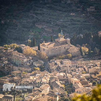
Mallorca: Hike on the Cami de S'Arxiduc from Valdemossa to Deià
- Mar 14, 2024
- 6 min read
Updated: Jul 16, 2024

The famous Archduke Ludwig Salvator Cami de S'Arxiduc bridle path from Valldemossa to Deia is undoubtedly the crowning glory of any coastal hike in Mallorca - the views of the sea and the mountains are simply spectacular!
One of my favorite places is the Mirador de ses Puntes
which sits on a rocky spur behind a Moorish-looking façade and from which you have a breathtaking deep and wide view.
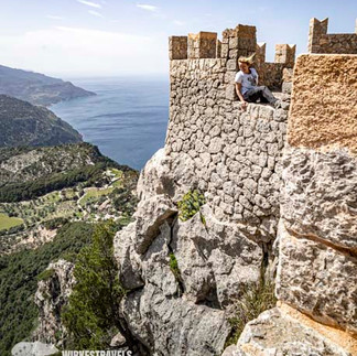
Other highlights of this hike in Mallorca are the Refugi de S'Arxiduc and the hermit cave Cova de s'Ermità Guillem and of course the Cami de S'Arxiduc itself, which leads along an exposed rocky ridge 800 meters above sea level.
This variant leads over private property – see starting point.
Key facts about the hike on the Cami de S'Arxiduc/Mallorca

♡ -Factor: ♡♡♡♡♡
Walking time : 3:30h
Altitude : 610 m up, 860 m downhill
Length : 11.5 km
Accessible by public transport? Bus 203 connects Port de Sóller with Palma, passing through Deia and Valldemossa. Timetable: www.tib.org/de
Suitable for families? The path itself is not particularly difficult, but it is quite exposed and partly unsecured on a steep cliff.
Stop along the way? Only at the start and end points in Valldemossa or Deia
GPS data: I have uploaded the GPS data for the hike to the Outdoor Active website
Starting point: The hiking trail begins at the end of Carrer Oliveres. ATTENTION: The hike starts on private property; to protect the black vultures and nature, the number of visitors is limited. To do this, hikers must pass a checkpoint at Finca Son Moragues, where they will also be informed about protective measures. Before the hike you should get a permit at least 2 days in advance (Monday to Friday from 9 a.m. to 2 p.m. By WhatsApp on +34-619 59 19 85 or by email: info@muntanyadelvoltor.com ) More information about this project : www.muntanyadelvoltor.com
VARIANT
If you don't want to go down to Deia, you can also do this tour as a circular route back to Valldemossa. At the crossroads where it leads left down to Deia, continue along the bridle path. At the Pla des Artiges there are two options: 1. back to the starting point via the Cami des Fontanelles, or the big loop via the Refugi de Son Moragues (if you want you can also take the summit climb of the Puig des Teix (1064m) with you). This path also ends in Valldemossa - but on the other side of the village.
Mountains or sea? BOTH works in Mallorca
On the largest of the Balearic Islands, you can easily combine summit happiness and swimming in the sea. You usually have a more or less close view of the sea during the hikes. Especially with the many coastal hikes, you can also hike along challenging paths along the tempting turquoise sea.
A very famous coastal path is the hike from Valldemossa to Deia. The landscape is so breathtaking that the Austrian Archduke Ludwig Salvator had a bridleway built here in the 19th century. The route is so exposed that even as a rider I would 100% prefer to walk here than sit on a nervous horse.
400 meters above the Mediterranean, the “Cami de Arxidux” follows directly the edge of the cliff.
From here you have gigantic views of the cliffs over Deia to the rocks of Puerto Sóller. My personal highlight is the “Sa Foradada” peninsula with a 14 meter hole in the middle of the rock. Here you can enjoy a drink with a great view at sunset (or before) after a long hike. The previously mentioned Archduke loved the island and had a knack for finding the most beautiful places. No wonder that he had his mansion “Son Marroig” built on this site . The good man definitely had taste.


INFO

GETTING THERE
By plane :
Palma de Mallorca Airport is served by numerous airlines from all major airports in Germany, Austria and Switzerland. The flight time is around 2 hours.
A flight produces CO₂. You can calculate and compensate for the CO₂ footprint of your flight on the website: https://www.atmosfair.de/en/
With the ferry :
A ferry crosses from Barcelona to Palma once or twice a day all year round; The journey time is around 7 hours, with the express ferry just under 4 hours.
You can book the various providers via www.directferries.de , for example .
By train :
Mallorca can also be reached in a climate-friendly manner by train and ferry:
From western or northern Germany, the best connections are via Paris. From Paris you also take the TGV to Barcelona, where you board the ferry (the Balearia, Iscomar or Acciona lines) to Mallorca.
GET AROUND
Some of the bus connections in Mallorca are only designed for hikers in the high season. Timetables and prices can be found at www.tib.org .
To be a little more flexible, we recommend renting a car (for example via www.billiger-mietwagen.de ). However, some hikes are not designed as circular routes, so you either get on a bus or take a taxi for the return trip . There are taxi ranks in all larger towns, and the fixed prices are often advertised on a board at the taxi rank.
SLEEP

In my blog post:
I'll tell you where the most beautiful accommodation can be found.
The best starting point for the high mountains and also some coastal hikes is the Sóller Valley, or Puerto Sóller. Sant Elm is recommended for the south and Pollença for the north.
Mallorca is the largest island in the Balearic Islands - if you live in the “wrong place”, the journey can sometimes be quite long. It is therefore best to check in which area you would like to hike the most before booking, or to change accommodation once during your stay.
Those who do the GR221 walk from hut to hut, but the beautifully located, relatively inexpensive refugios are also a good choice for “normal” day tours :
In addition to the usual providers such as www.booking.com or https://www.airbnb.co.uk there are also some providers specializing in Mallorca:
The website www.fincaferien.de (only in german) has a large selection of self-catering accommodation on all Spanish islands.
www.fincasmallorca.de specializes in renting houses around the Sóller Valley.
BEST TIME
The best time for hiking is between mid-February and the end of May. From June to mid-September it is often quite hot. From September to the end of October the island is no longer quite as green, but the sea is still warm enough for swimming.
With 300 days of sunshine a year, the weather in Mallorca is rarely really bad for several days. On rainy days, the Serra de Tramuntana is often a weather divide. This means that if it is bad in the west, the weather in the east can be passable - and vice versa.

LITERATURE
Roth hiking guide revised edition 2021
MAPS
A good hiking map is the Kompass hiking, cycling and leisure map at a scale of 1:75,000, which is also available locally.
For the Tramuntana hiking region, the three sheets “Mallorca Tramuntana Central”, “ Mallorca Tramuntana Nord ” and “ Mallorca Tramuntana Sud” from Editorial Alpina on a scale of 1:25,000 are the best choice. The map “ Vall de Sóller ” (1:15,000), also published by Alpina, is ideal for the Soller region. The Alpina map “ Mallorca North ” (1:25,000) covers the north.
EQUIPMENT
We recommend hiking boots with good tread (otherwise the paved paths can become quite slippery...), rain and sun protection , and - for cooler days - warm clothing. Long, thin trousers or knee-high socks , because the tours, which are not used very often, lead through tall grass that can scratch your legs.


Comments